 Customizable GIS portal
- Provides zero code customization, and visual operation can easily switch portal style.
- Provides full code customization to deeply build a dedicated GIS portal.
-
Multiple built-in GIS function modules can be flexibly configured, and can also be deeply customized and developed to quickly respond to business needs.
 GIS resource integration and management
-
Supports the registration and access of various OGC services, internet maps and REST services of mainstream heterogeneous GIS platforms.
- Supports Excel, CSV, UDB, SuperMap workspace, Shapefile, SMTiles, TPK, GeoJSON data uploading and displaying.
- Supports user-managed data storage for PostGIS, PostgreSQL, and MySQL databases for registered users.
- Supports multiple ways to retrieve GIS resources, such as fuzzy search, classification filtering, geospatial range filtering.
- Supports unified control of multi-source GIS Service permissions.
-
Supports GIS resource quota and GIS resource sharing and collaboration with multiple users and terminals.
 DataViz WebApp
It is a lightweight and high-efficient data visualization application, providing thematic map making, streaming data visualization and map printing, which can realize Web map making and sharing.
 MapStudio WebApp
It is a GIS application running on the Web. It provides rich GIS capabilities. It is used for rapid mapping, spatial analysis, and spatial data editing on the Web. At the same time, based on vector tile rendering technology, it provides a smooth map browsing experience.
- Supports web symbol mapping to enhance industry map production.
- New templates for point layers, line layers, polygon layers, composite symbols, heatmaps, and clustering maps.
- Supports configuring REST, WMTS, WMS services, and various domestic and international internet maps as base maps.
- Enables configuring layer styles, offering visual effects for 2D, 3D, and animations.
-
Supports grid aggregation, area aggregation, overlay analysis, and other processing tools to extract spatial information value.
 DataInsights WebApp
It is a geospatial data analysis Web application. It can realize online visualization and analysis of geospatial data through interactive operation. It integrates SuperMap iServer distributed analysis and data science service, and supports extension to help users dig the value of geospatial data.
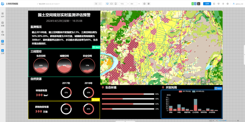
 MapDashboard WebApp
It is a Geological data visualization dashboard application. It can display the location analysis in the way of intuitive and interactive visualization, which can help decision making, visualization trend analysis, real-time monitoring and spatio-temporal playback analysis.
- New multi-user real-time collaborative editing capabilities, supporting version history and recovery.
- Supports map and scene switching between different pages, facilitating multi-perspective map and scene displays.
- Enhances industry application templates for sectors like electric power and petrochemicals.
- New data filtering, time selection, etc.
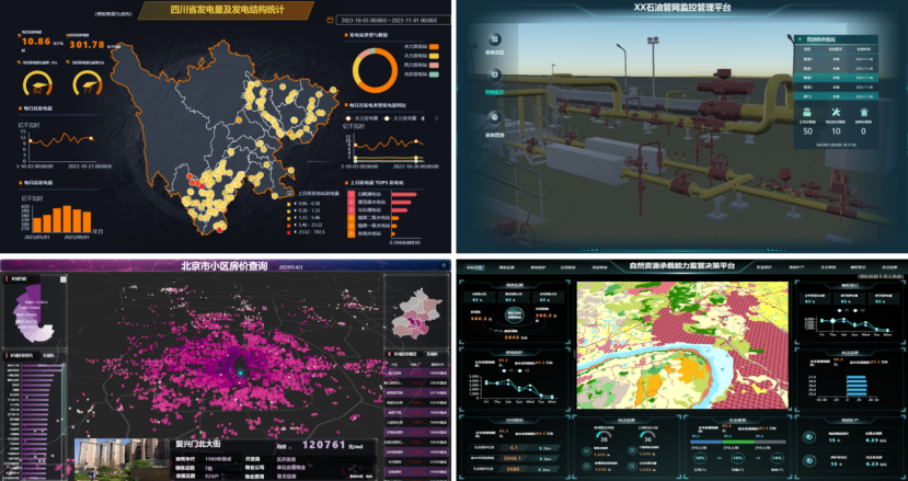
Provides multiple industry application templates
Real-time collaborative editing for multiple users
 GPAModelBuilder WebApp
It is a processing automation web application that quickly builds business process models, and helps realize automate complex data processing and analysis processes.
- Supports customizable UI styles and custom operator parameter configuration UI.
-
Supports data resource directory where users can drag data nodes into modeling workflows as variables.
 iEarth WebApp
It is a full-featured 3D WebApp developed using SuperMap iClient3D for WebGL, offering plugin-free and excellent compatibility features. It provides efficient loading and management of heterogeneous 3D data from multiple sources, enabling rapid construction of 3D visualization scenes. Users can browse, query, analyze, and share scenes online seamlessly.
- Provides multiple public services, online base maps, and online terrain for quickly building 3D scenes.
- Public services now include city detailed model data with built-in PBR effects.
- Supports loading terrain, imagery, oblique photography, 3D models, point clouds, BIM, city detailed models, architectural wireframe data, point/line/area, and other heterogeneous spatial data sources.
- Supports for viewing and paginating attribute tables of data services, enabling interactive display of data attributes in both 2D and 3D.
- Provides extensive 3D analysis, querying, and measurement functionalities, including line of sight analysis, distance/height/area measurements in multiple measurement modes, and oblique monomer queries.
- Supports adjusting scene properties such as shadows, brightness, enabling underground views, and newly added capability to save and reopen pre-configured scene properties, facilitating quick restoration of scene visualization effects.
- Provides 3D flight simulation capability, with added support for locally saving custom flight route files.
- Provides 3D special effects including lighting, scene ambient lighting, rain and snow effects, enhancing scene realism.
- Provides functions such as split-screen, curtain effect, and video projection to achieve scene interaction and management.
- Supports custom addition of internationalization resources and addition or deletion of services through configuration files.
- Supports creating and saving flat scenes.
- Supports overlaying map services or video files with oblique photography and 3D model display.
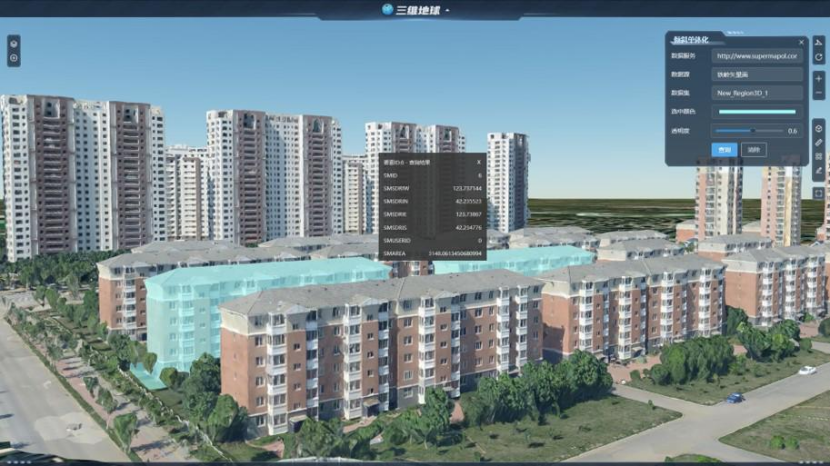
Oblique photography 3D model individualized querying
 iDesigner3D WebApp
It is a lightweight 3D WebApp developed based on SuperMap iClient3D for WebGL, with online rapid modeling and multiplayer interactive editing capabilities based on real geographic environments, empowering industries such as urban design and digital transportation.
-
Supports loading of online terrain data, image data, S3M tiles data, etc.
- Supports loading online vector data for modeling, with added support for loading data in GeoJSON format.
- Supports rapid batch construction of 3D models such as buildings, roads, pipelines, tunnels, and ditches based on vector data and modeling rules.
- Supports model material editing, model parameter editing, style settings, and allows real-time updating of editing and setting results.
- Provides project management capabilities, including automatic saving, sharing, downloading, viewing, and re-editing of modeling results. Newly supports permission settings and service configuration.
- Provides a material editor supporting online creation, renaming, deletion, editing, and sharing of standard materials and PBR materials.
- Provides scene auxiliary operation tools, including view switching, selection editing, and distance/height/area measurements.
- Provides scene editing and browsing tools, including tilt operations, adding model objects, annotation plotting, scene roaming, and viewpoint management.
- Provides scene effect adjustment capabilities, supporting settings for scene properties such as sun position, as well as parameters for rainy, snowy, and skybox conditions.
- New examples for building extrusion, road profiling, and supports custom re-editing of examples.
- New functionalities for sunlight analysis and cut and fill analysis.
- Provides internationalization resources, supporting switching between Chinese, English, and Japanese.
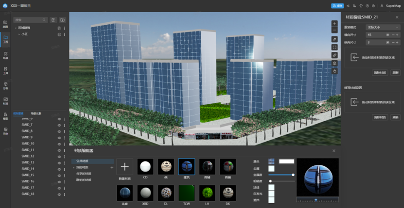
The modeling results support PBR materials, enabling more realistic representation of buildings.
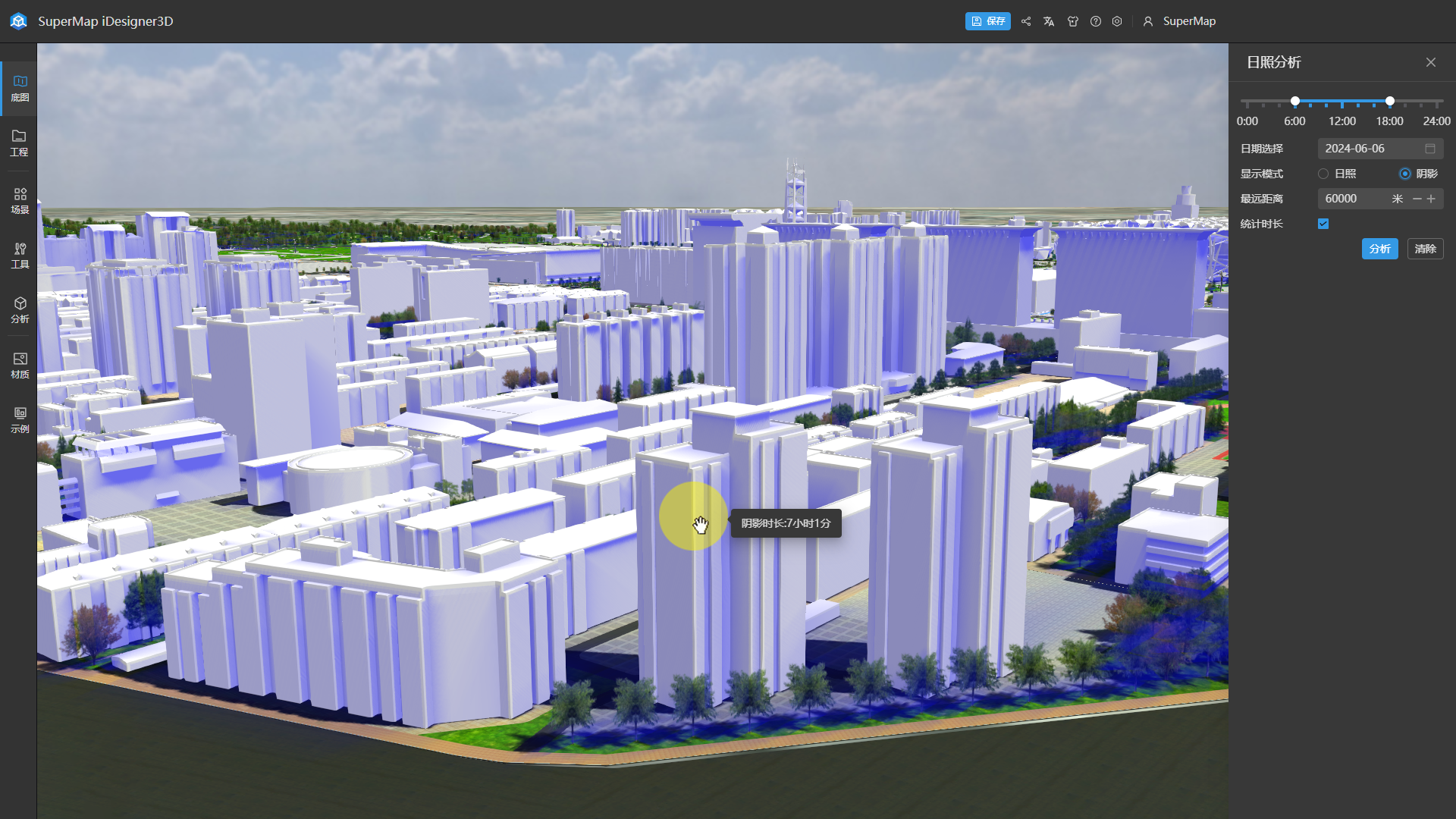
Supports sunlight analysis with analysis results conforming to model surface display.
 SuperMap Copilot WebApp (preview version)
It is a natural language interaction WebApp based on a large NLP model and AI Agent technology. It incorporates the ability to interactively call GIS tools through conversation, enabling retrieva1, analysis, visualization, and other capabilities from portals or third-party resources.
- Supports conversational portal resource retrieva1 capability, capable of identifying and executing various retrieva1 requests based on keywords, tags, resource types, etc.
-
Supports conversational data analysis capability, capable of identifying and executing statistical analysis requests for data such as count, sum, maximum, minimum, average, and median. It can also recognize and execute spatial analysis requests such as overlay analysis.
-
Supports conversational data visualization capabilities, capable of recognizing and executing requests to generate statistical charts such as pie charts, bar charts, radar charts, histograms, and line charts, as well as generating maps such as basic maps, single-value thematic maps, graduated thematic maps, and heatmaps. It also supports secondary editing of maps through controls.
-
Supports conversational portal management capabilities for administrator users, capable of recognizing and executing user management requests and portal resource management requests.
- Supports administration of tool directories (in API form), allowing configuration and addition/deletion of internal or third-party APIs.
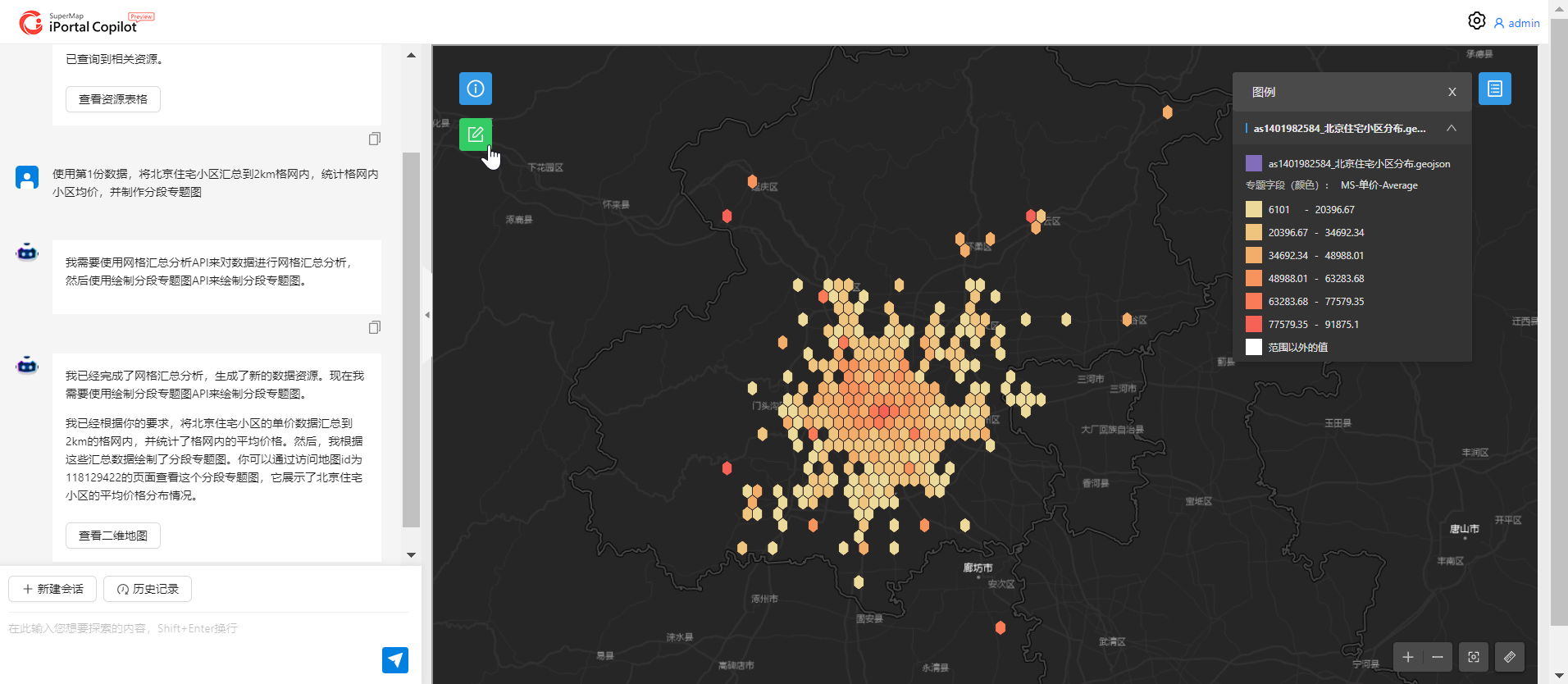
SuperMap Copilot processes user requests, utilizing GIS tools for analysis and mapping.