Pix4D
Pix4D is a professional photogrammetry software used for processing aerial images and generating high-precision 3D models, point clouds, orthophotos, Digital Elevation Models (DEM), etc. It is widely applied in industries such as surveying and mapping, architecture, agriculture, security, and mining.
Products

Photogrammetry software for professional UAV mapping.

Bridging photogrammetry and CAD.
Enabling larger-scale photogrammetric projects.
Agriculture
Conduct aerial farmland mapping and crop analysis from an aerial perspective, specifically designed for digital agriculture.

Public Safety
A rapid mosaicking software for emergency response.

OEM / Integrators
Leverage our photogrammetric reconstruction engine to build the future of digital reality.
Core Competencies

High-precision Modeling
Build 3D models with centimeter-level accuracy using the images captured by drones.

Intelligent Image Processing
Automatically identify and correct image errors to improve data quality.

Powerful GIS Compatibility
It can be seamlessly integrated with software such as ArcGIS, QGIS, AutoCAD, Revit and so on.

Support for Multiple Data Formats
It can export point clouds (LAS), mesh models (OBJ), Digital Elevation Models (DEM in GeoTIFF format), etc.
Which Fields is it Applicable to?
Surveying and Mapping / GIS

Generating High-Precision Digital Terrain Maps (DTM/DSM)
Land Surveying
Architecture / BIM

Construction Progress Tracking
Architectural Facade Surveying
Agriculture

NDVI Image Analysis
Crop Health Monitoring
Mining / Quarries

Mine Volume Calculation
Slope Stability Analysis
Environmental Monitoring

Flood Simulation
Forest Health Assessment
Security / Public Safety

3D Restoration of Accident Scenes
Disaster Emergency Response
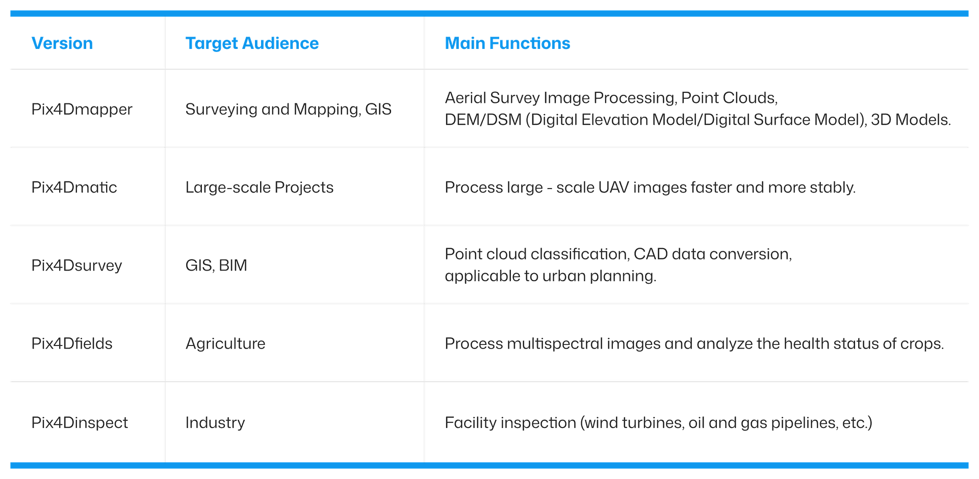
Software Version Comparison
Pix4D is actually not just one software. Different versions are suitable for different needs.