
Our Smart Site Supervision System (SSSS) is powered by the flagship product Geosys VR3D Platform, which is a Centralized Platform integrating Deformation Management System, DWSS, Photo Management System, IoT Systems with its 3D Data Management System with System Administration capabilities.
Our Solution
Smart Site Supervision System (SSSS)
3D Reality Model in 3D Data Management System
- UAV Photogrammetry Service for 3D Reality Model Formation
- Create 3D Reality Model in 3MX/OSGB with Survey Control Points
- Navigate to control 3D Reality Model with Shortcuts and Markers in 3D Viewer
- Integrate 3D Reality Model with various formats of 2D/3D CAD, BIM, and Reality Meshes
- Compare and Overlay Models with Adjustable Transparency
- Measure Coordinate, Distance, Elevation, Area, and Volume with Reality Model
- Add and Remove BIM or 3D Models in vicinity to the Site with Photorealistic Mesh Model
- Integrate with 2D Base Map, Drawings, Documents, Numerical Data, and Media in Various Formats
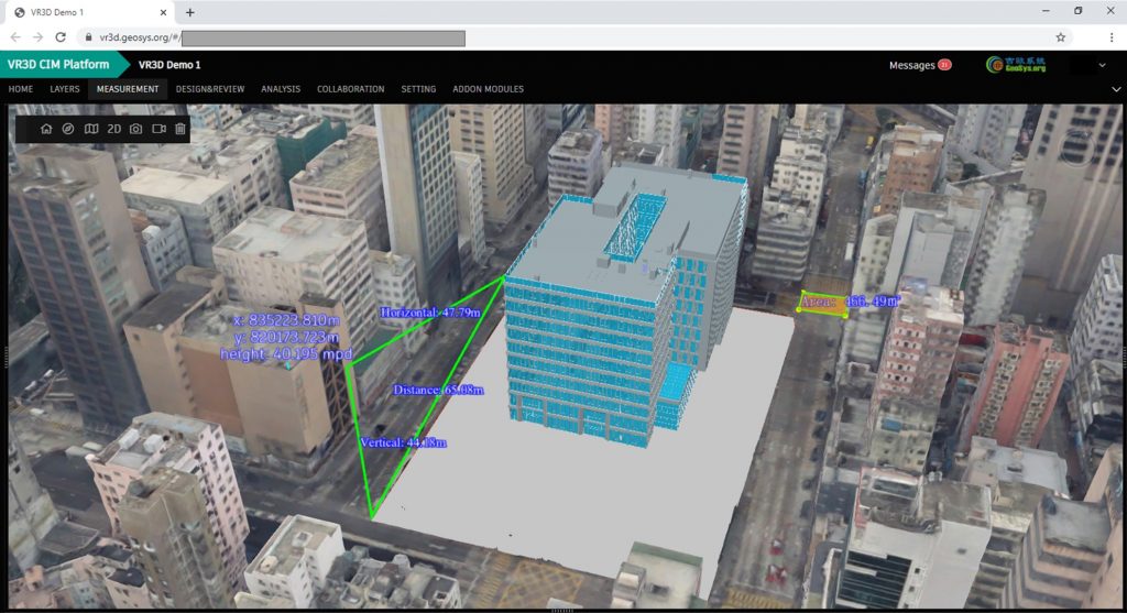
Photo Management System
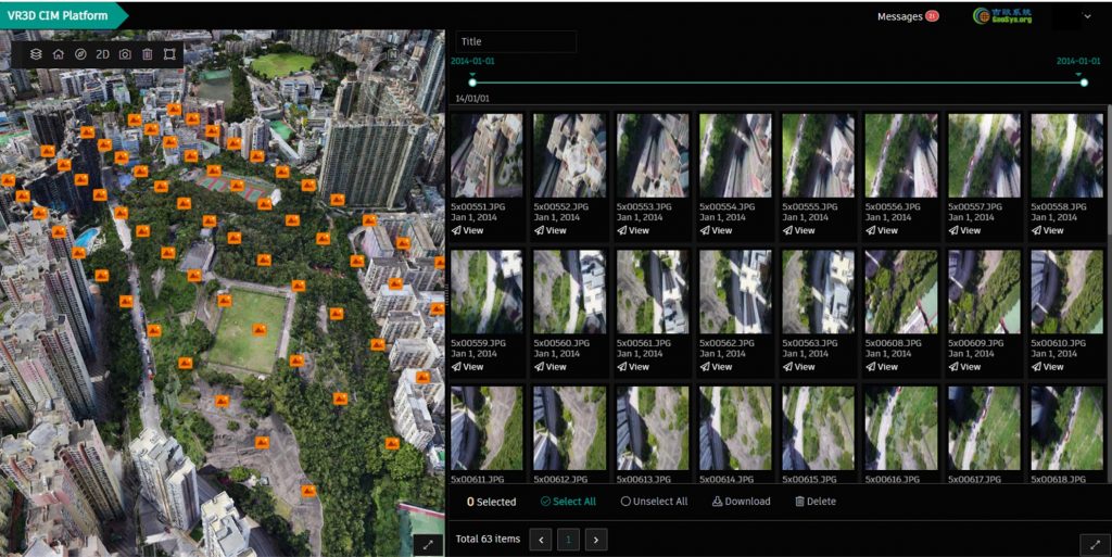
- Enable Georeferenced Photos in 3D GIS Environment with BIM
- Stream, Review and Navigate with Your Images Online
- Manage and Filter Images on Web-based Photo Gallery
Deformation Management System
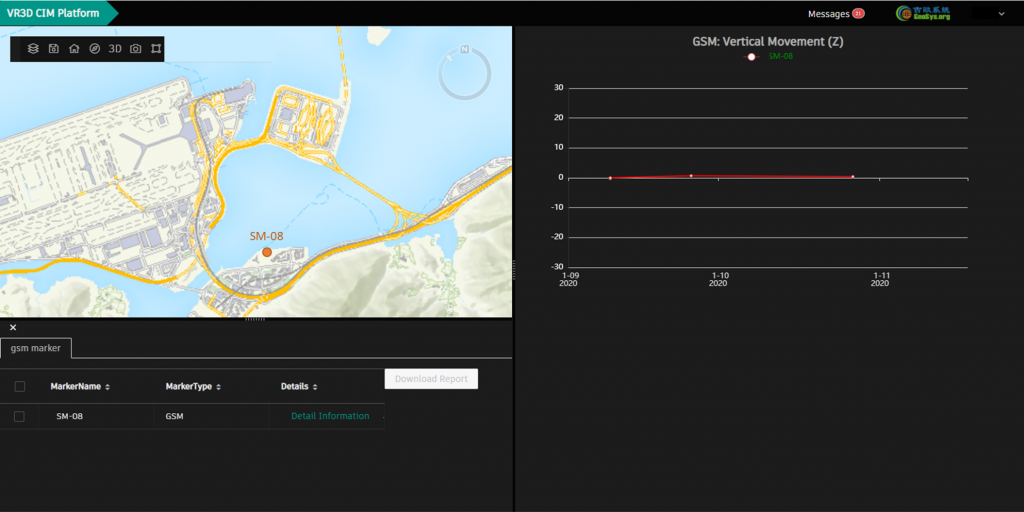
- Present Data in Tables and Charts
- Set Alarm, Alert, Action (AAA) for Specific Data Value(s)
- Auto Notification to Users When Reaching AAA Threshold
IoT Integration System
- Integrate with Third-party IoT Devices Systems by API to Display Real-time and Historical Data of Various Devices, e.g. Smart Helmets, Proximity Sensors, Environmental Monitoring Sensors, etc.
- Interact 3D Data with Tables/ Charts
- Set Alert for Specific Data Value(s)
DWSS Integration
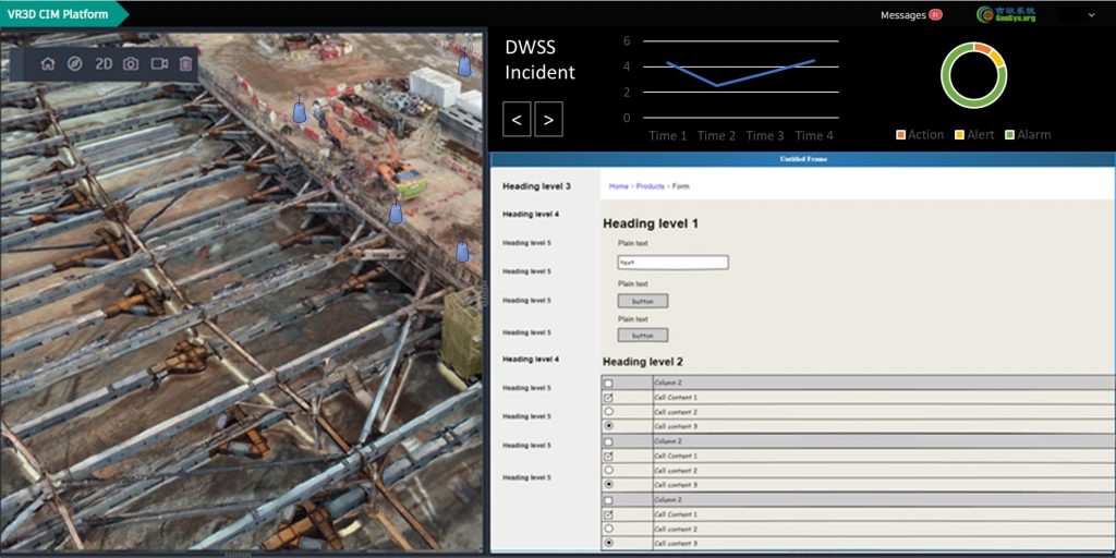
- Integrate with Third-party RISC Form and Safety Inspection Form by API
- Incorporate Geotagged Forms and Related Data with Models in 3D Environment
System Administration
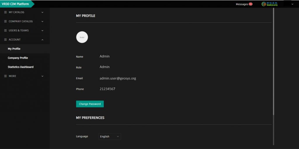
- Enable encrypted password with password setting rules and change mechanism
- Retain Audit and history log in backend server
- Provide User Roles with Different User Privileges for no less than 100 Users
- Manage Files with Sorting, Filtering, and Searching Functionalities
Our Solution
Workflow
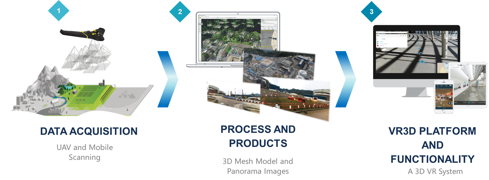
Data Acquisition
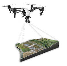
UAV Mapping
Mapping drones, which boast quick data collection times, excellent positional accuracy and a safe operator experience.
Drone technology is both reducing the risk and boosting the working efficiency. What’s more, it is safe and secure throughout the period of flying.
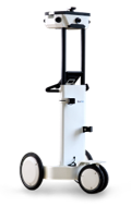
Indoor Mobile Laser Scanning
NavVis M3 is used to capture the largest indoor environment.
This system is designed for large-scale scanning projects. Point clouds and 360° immersive imagery can be automatically captured when walking through a building.
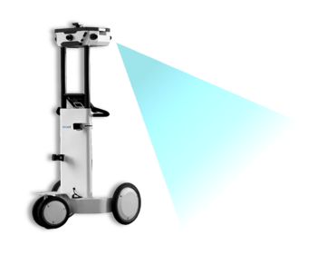
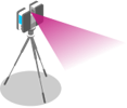
Outdoor Mobile Laser Scanning
A vehicle and application independent reality capture sensor achieves the efficient mobile surveying.
It is a powerful platform that combines laser scanner with high-resolution and measurable camera.

Deliverables and Development
Benefits and Key Features

Efficent, effective and simplified 3D scanning: Capture up to 30,000 square meters a day with mobile scanning. The M6 automatically captures reality as it is pushed through indoor environments.

Scan to BIM: Build facilities management solutions to monitor equipment usage, manage energy systems, lower operational response times, increase occupant engagement and overall building safety with indoor positioning.
")
Detailed, realistic 3D representation: 360 degree immersive images and photorealistic point clouds create highly detailed digital factories that you can walkthrough virtually from anywhere.

Intuitive, powerful functions in brower-based platform: Add, edit, search and share comments and geo-tagged information with the point of interest function. Take accurate measurements and plan your indoor routes. Digital footplans can also be accessed.
Data Acquisition

-
Mobile Laser Scanning
-
Stationary Laser Scanner
-
Surveying
-
Inventive Approach
-
Efficient and practical workflow
-
Valuable results
We adopted a more innovative and efficient method for data retrieval that combination of mobile laser scanner, stationary laser scanner and total station. This integration providing high resolution result is significantly beneficial to further data processing.
Deliverables
What’s included

360 degree immersive images and photorealistic point clouds create highly detailed digital factories that you can walkthrough virtually from anywhere.

Generate 3D point clouds of large buildings in record time, immediately compatible with any CAD software – conveniently generate BIM models or floorplans for existing structures.

Intuitive, powerful functions in brower-based platform: Easily integrate your existing apps or websites to streamline user experience. Achieve what you want to do on the platform.
Features and Development

Detailed, realistic 3D representation: 360 degree immersive images and photorealistic point clouds create highly detailed digital factories that you can walkthrough virtually from anywhere.

Positioning and Navigation: See your position on the map and navigate to your desired location. Follow the step-by-step directions on a virtual path.

Intuitive, powerful functions in brower-based platform: Add, edit, search and share comments and geo-tagged information with the point of interest function. Take accurate measurements and plan your indoor routes. Digital footplans can also be accessed.
- Smart Site Supervision System (SSSS)
-
Our Solution
Smart Site Supervision System (SSSS)
Our Smart Site Supervision System (SSSS) is powered by the flagship product Geosys VR3D Platform, which is a Centralized Platform integrating Deformation Management System, DWSS, Photo Management System, IoT Systems with its 3D Data Management System with System Administration capabilities.
3D Reality Model in 3D Data Management System
- UAV Photogrammetry Service for 3D Reality Model Formation
- Create 3D Reality Model in 3MX/OSGB with Survey Control Points
- Navigate to control 3D Reality Model with Shortcuts and Markers in 3D Viewer
- Integrate 3D Reality Model with various formats of 2D/3D CAD, BIM, and Reality Meshes
- Compare and Overlay Models with Adjustable Transparency
- Measure Coordinate, Distance, Elevation, Area, and Volume with Reality Model
- Add and Remove BIM or 3D Models in vicinity to the Site with Photorealistic Mesh Model
- Integrate with 2D Base Map, Drawings, Documents, Numerical Data, and Media in Various Formats
Photo Management System
- Enable Georeferenced Photos in 3D GIS Environment with BIM
- Stream, Review and Navigate with Your Images Online
- Manage and Filter Images on Web-based Photo Gallery
Deformation Management System
- Present Data in Tables and Charts
- Set Alarm, Alert, Action (AAA) for Specific Data Value(s)
- Auto Notification to Users When Reaching AAA Threshold
IoT Integration System
- Integrate with Third-party IoT Devices Systems by API to Display Real-time and Historical Data of Various Devices, e.g. Smart Helmets, Proximity Sensors, Environmental Monitoring Sensors, etc.
- Interact 3D Data with Tables/ Charts
- Set Alert for Specific Data Value(s)
DWSS Integration
- Integrate with Third-party RISC Form and Safety Inspection Form by API
- Incorporate Geotagged Forms and Related Data with Models in 3D Environment
System Administration
- Enable encrypted password with password setting rules and change mechanism
- Retain Audit and history log in backend server
- Provide User Roles with Different User Privileges for no less than 100 Users
- Manage Files with Sorting, Filtering, and Searching Functionalities
- Aerial and Terrestrial Scanning
-
Our Solution
Workflow
Data Acquisition
UAV Mapping
Mapping drones, which boast quick data collection times, excellent positional accuracy and a safe operator experience.
Drone technology is both reducing the risk and boosting the working efficiency. What’s more, it is safe and secure throughout the period of flying.
Indoor Mobile Laser Scanning
NavVis M3 is used to capture the largest indoor environment.
This system is designed for large-scale scanning projects. Point clouds and 360° immersive imagery can be automatically captured when walking through a building.
Outdoor Mobile Laser Scanning
A vehicle and application independent reality capture sensor achieves the efficient mobile surveying.
It is a powerful platform that combines laser scanner with high-resolution and measurable camera.
Deliverables and Development
Benefits and Key Features
Efficent, effective and simplified 3D scanning: Capture up to 30,000 square meters a day with mobile scanning. The M6 automatically captures reality as it is pushed through indoor environments.
Scan to BIM: Build facilities management solutions to monitor equipment usage, manage energy systems, lower operational response times, increase occupant engagement and overall building safety with indoor positioning.
Detailed, realistic 3D representation: 360 degree immersive images and photorealistic point clouds create highly detailed digital factories that you can walkthrough virtually from anywhere.
Intuitive, powerful functions in brower-based platform: Add, edit, search and share comments and geo-tagged information with the point of interest function. Take accurate measurements and plan your indoor routes. Digital footplans can also be accessed.
- Indoor Mapping
-
Data Acquisition
-
Mobile Laser Scanning
-
Stationary Laser Scanner
-
Surveying
-
Inventive Approach
-
Efficient and practical workflow
-
Valuable results
We adopted a more innovative and efficient method for data retrieval that combination of mobile laser scanner, stationary laser scanner and total station. This integration providing high resolution result is significantly beneficial to further data processing.
Deliverables
What’s included
360 degree immersive images and photorealistic point clouds create highly detailed digital factories that you can walkthrough virtually from anywhere.
Generate 3D point clouds of large buildings in record time, immediately compatible with any CAD software – conveniently generate BIM models or floorplans for existing structures.
Intuitive, powerful functions in brower-based platform: Easily integrate your existing apps or websites to streamline user experience. Achieve what you want to do on the platform.
Features and Development
Detailed, realistic 3D representation: 360 degree immersive images and photorealistic point clouds create highly detailed digital factories that you can walkthrough virtually from anywhere.
Positioning and Navigation: See your position on the map and navigate to your desired location. Follow the step-by-step directions on a virtual path.
Intuitive, powerful functions in brower-based platform: Add, edit, search and share comments and geo-tagged information with the point of interest function. Take accurate measurements and plan your indoor routes. Digital footplans can also be accessed.
-